We spent last night at the campground of Blackwater Falls State Park. I personally prefer to avoid state parks, especially on the weekends, due to crowds. True to form, Amanda and I were sandwiched between two large families with poorly behaved dogs and really loud kids. The redeeming quality of this campground was a phenomenal bath/shower house, with clean, powerful showers, though I’m not sure even that made up for the $45/night price for a non-electric campsite with no water. Regardless, the campsite gave us what we needed: close proximity to several waterfalls within the state park that we wanted to see.
Blackwater Falls
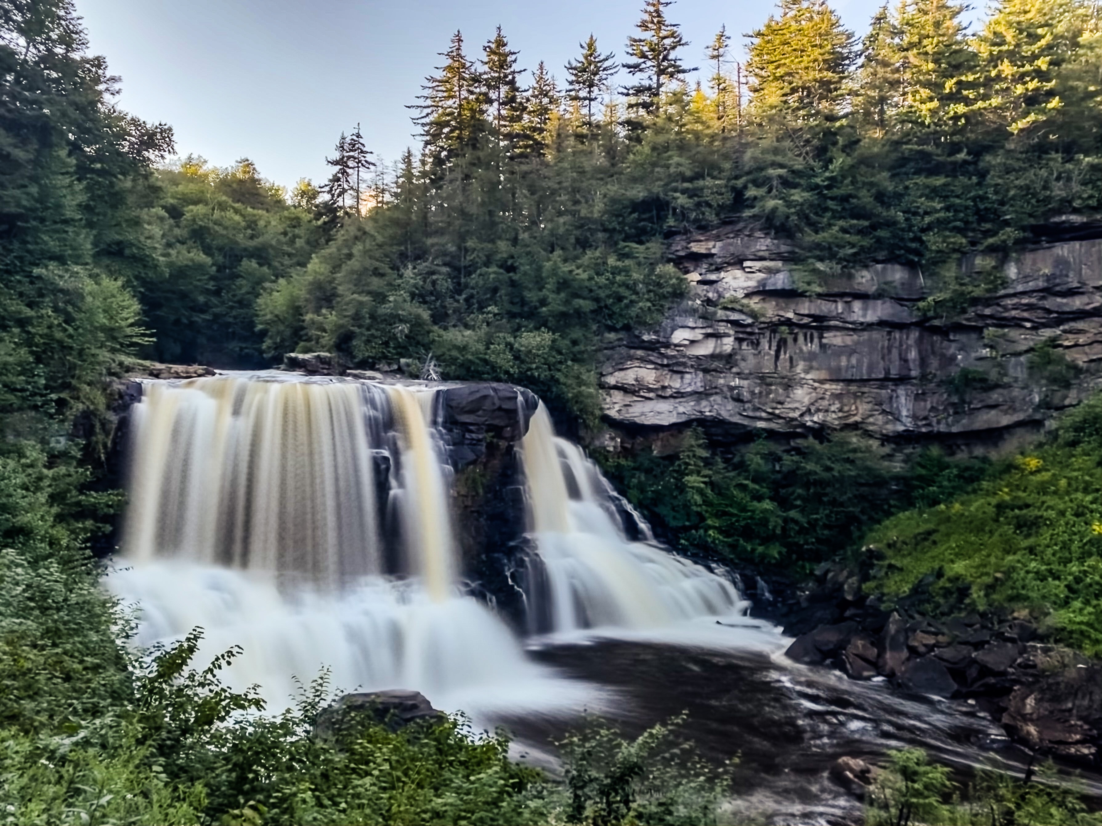
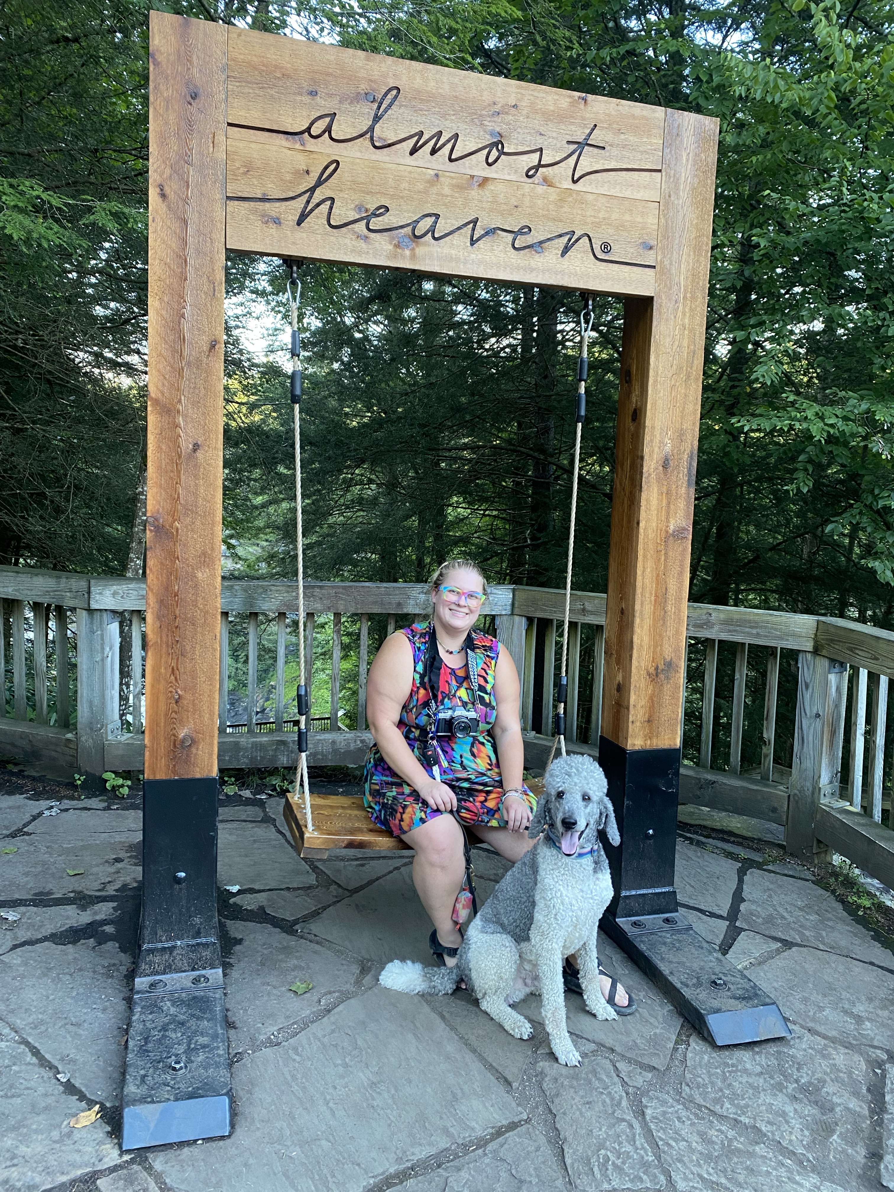
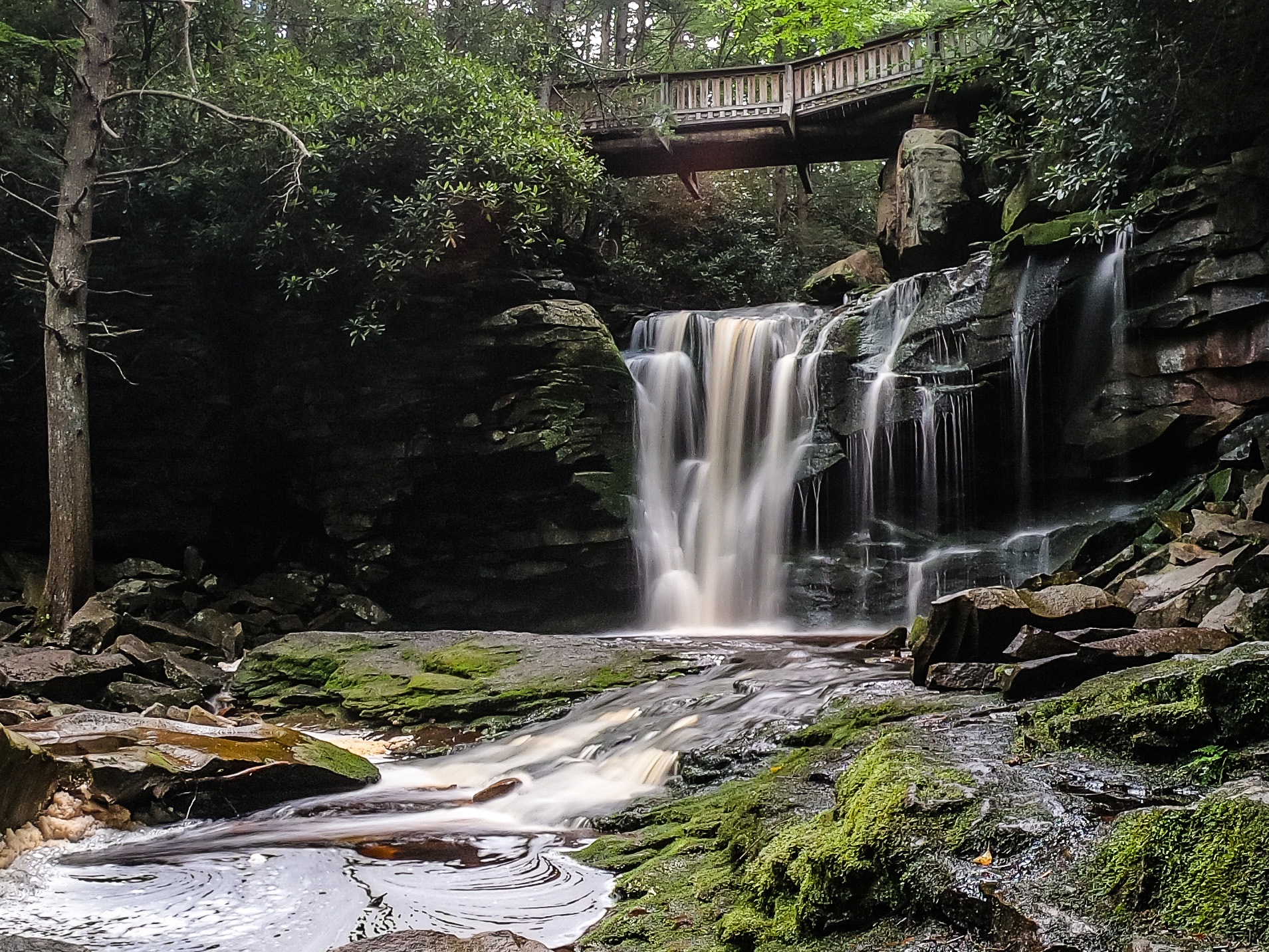
Blackwater Falls is one of the most iconic waterfalls in West Virginia. It’s the tallest in the state, and honestly it lives up to it’s reputation. Amanda and I actually hiked the “Gentle Trail” — an extremely short (less than 0.1 mile) paved trail to an upper overlook of the waterfall on river left– and the Blackwater Falls Trail down to the upper and lower overlooks last night before sunset. Usually, the extremely “built up” nature of this trail, with its pavement and it’s wooden overlooks and it’s boardwalks, would turn me off. But I have to say, the waterfall was so spectacular that it overshadowed all of this man-made infrastructure, and I’m grateful that some provisions are in place to allow as many people as possible to witness it’s beauty. The trail to the uppermost overlook, where the “almost heaven” swing is in the photo below, is wheelchair accessible.
Waterfalls on Shay’s Run
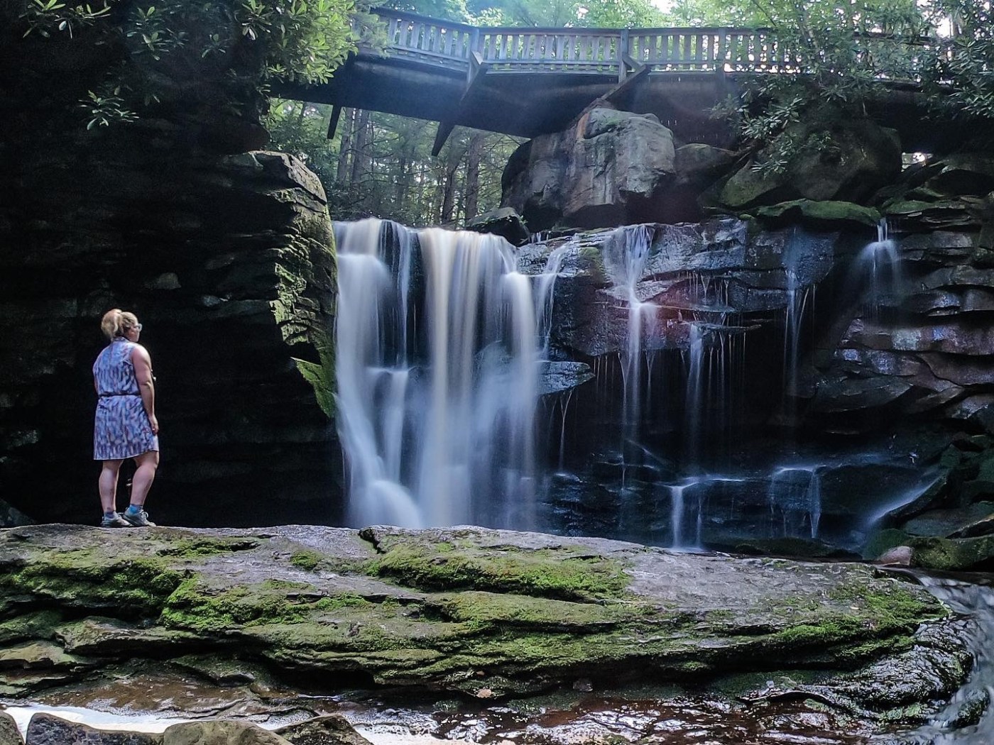
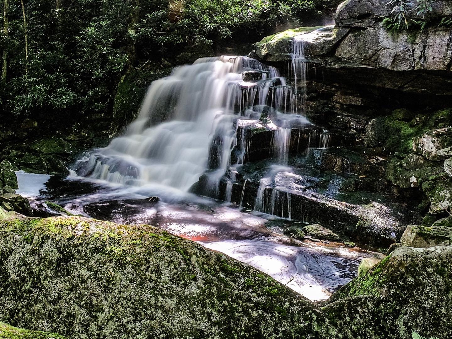
Today, we plan to visit Elakala Falls before leaving the state park for the less-trafficked national forest. Elakala Falls is the first waterfall on Shay’s Run, and the most famous. There are three other significant drops on this creek before it empties into the Blackwater River, but we only plan to visit the first two today. The other two require a pretty significant scramble/bushwhack to reach. This creek is gorgeous, and we spend a lot of time at the base of Elakala Falls and then scrambling around the second waterfall on Shay’s Run.
The trail to the bridge above Elakala Falls is not accessible, but is relatively straightforward, short, and easy. Getting to the base of Elakala (first photo below), and to the base of the second waterfall on Shay’s Run (second photo below) requires a slightly tricky rock scramble, but is worth it for the setting and the privacy. As pretty as it is though, by the time we are done I’m pretty eager to get out of the state park and on to less populated public lands.
Red Creek Trail
Red Creek Trail is in Dolly Sods Wilderness, and is our final destination for the day. We planned to do a 7 mile hike out to a couple of waterfalls I had pinned on my Gaia maps, looping around to complete a keyhole-loop hike. Fate is working against us, however, as we make it almost to the trailhead to find that the road is closed 0.5 miles from where we are supposed to park and we cannot access the trail system from this side. Turns out, this entrance to Dolly Sods has been closed all summer, but Google Maps didn’t seem to know that. Now, we are facing a nearly 1.5 hour detour to get around to the opposite entrance.
I don’t have cell signal and am sitting the side of a backroad looking at a map when a man drives by in a work truck and rolls his window down. “Y’all tryin’ to get into the Sods?” he asks. “Yeah, it looks like we need to come in from a different direction.” He’s the one who tells us the road has been closed all summer, and gives us directions around to a different entrance. His directions are spot on, and we find the other side with no issues, just a few less hours of daylight left.
We finally reach the trailhead for Red Creek and get started hiking. I’m trying out new creek-walking shoes and it’s evident by about a mile in that they are not working out. Either I’ve purchased the wrong size or these shoes are just not for my feet, but either way I’m developing a monstrous blister on the back of my left heel. We make it a little over two miles to a waterfall called “Stairstep Falls” or possibly “Tongue and Groove Cascades” (I’ve seen it called both in two different publications, but with the say gps waypoint) and it’s more of a drip than a waterfall. We decide to call it quits and turn around.
This trail is super pretty, and Red Creek is gorgeous, but my blister is bleeding and the waterfalls don’t seem to be flowing well. This is definitely a trail I’d like to return to during a wetter season, wearing different shoes and getting an earlier start in the day. There is so much to explore here.
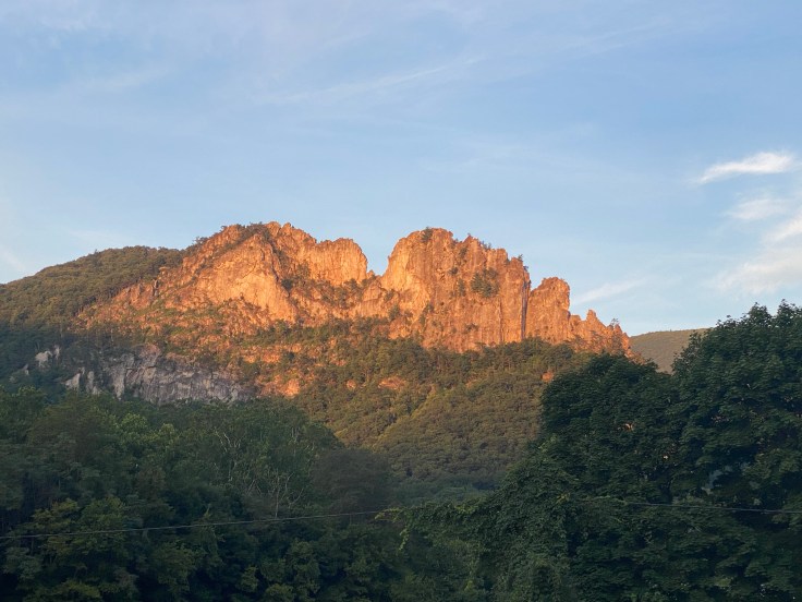
Back at the trailhead, Amanda decides to head home to Charleston. I’m planning to stay another couple days, so I drop her off at her car and head into the small “town” of Seneca Rocks to grab a burger for dinner while deciding where to camp for the night.
Seneca Shadows
The unincorporated town of Seneca Rocks can hardly be called a town. There’s a gas station that is also an inn, a grill, and a historical convenience store. Amanda and I actually stopped at “Harpers Old Country Store” on our way into Dolly Sods Wilderness earlier today to verify our directions, use the restroom, and pick up a few stickers. Since there’s no cell signal we wanted to be VERY sure we were headed in the right direction. We were cheerfully greeted by a kind woman who drew us a map and gave us great directions to where we were trying to go. This old store, built and continuously in business since 1902, is something of a historical and cultural treasure.
Next door to the store, “Yokum’s Vacationland” boasts rooms for rent, camping supplies for sale, and a limited-menu grill. Since this seems to be the only eatery in town, it’s where I decide to get dinner. I grab a burger and a tallboy Seaquench Ale and head out onto the back porch to plan my evening. I enjoy the company of two fat white cats and sunset views of the rock formations while bumming wifi and deciding where to sleep tonight. A few miles away is a campground called “Seneca Shadows” which has some first-come, first-served sites. I’ll sleep there tonight, and figure out tomorrow as it comes.